

In the West It’s Always Wildfire Season and Time to Update Your CWPP
Geospatial Data and Intelligence Solutions
Bintel has been incorporating geospatial datasets into intelligence solutions for the past four years. These data provide context and perspective that facilitates greater awareness and understanding for decision makers. Capabilities are progressing at a rapid rate, coming from new remote sensing and earth monitoring technologies, applied research from private industry and public institutions, and the bridging of physical and computer sciences. All these efforts are enabling new and exciting ways to effectively support decision-making in areas that are of high value and high consequence.The utility of these data are realized by a wide range of end-users in a diversity of domains. For example, ISR (Intelligence, Surveillance, Reconnaissance) on the battlefield, site monitoring for critical infrastructure, simulations for wildfire spread, measuring and evaluating carbon sequestration, precision agriculture, and so on. The applications are as vast as the number of activities that involve a specific location at a specific point in time. All of them, however, face similar challenges to using geospatial data for their specific functions. These are: 1) large volumes of data, 2) many types of data, 3) distribution of data sources, 4) scalable processing and analyzing data in a timely manner, and 5) making the output useable, easy to access, and easy to understand.
The Geospatial Intelligence Process
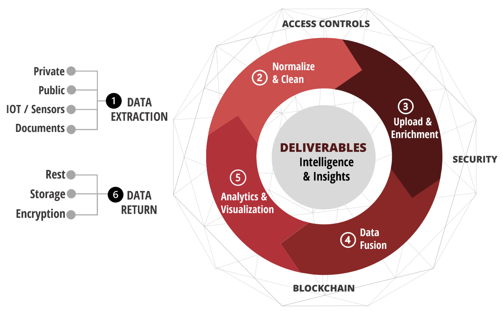
One application that has significance and importance to Bintel and our partner AAM is geohazard risk identification and monitoring. Our company and the homes of many of our employees are in areas that are greatly impacted by several geohazard risks, many of which are related. These include wildfires, floods, landslides, avalanches, and wind events. Our Geospatial Intelligence Stack™ (coming soon) is designed to directly address a significant obstacle faced by communities located in harm’s way of these forces. Specifically, the problems of identifying and harnessing the vast amount of data available, converting it into actionable intelligence and insights, serving myriad stakeholders, and making the whole process dynamic, interactive, and approachable. For Bintel, our focus on this area is more than just applying technology to other’s efforts in geohazard risk mitigation. We have a strong sense of purpose and meaning engaging in this work. We’re driven to help make our communities safer, our environment more resilient, and the livelihoods of community members more secure.
So what does it look like? The answer to that question will depend on the user(s), the use case(s), and the area(s) of interest. Whether applied to geohazard risk, commercial real-estate asset management, corporate sustainability and ESG (Environmental, Social, Governance) initiatives, agricultural activities, or ISR – if it involves a place and time, we can bring it into clear view for your needs. Contact Bintel to learn more and start the conversation on how our Geospatial Intelligence Stack™ can support and enhance your work.

Tom has served as CEO of Bintel since cofounding the company in 2019. Prior he was COO of ai-one inc. where he led projects for NASA Marshall, SwissRe, Boeing and FedEx. For the past 15 years he has specialized in artificial intelligence applications for enterprise and government with a critical integration of Subject Matter Experts, AI, data, and visualizations. A project with an Army military intelligence group for the development of a Nextgen intelligence platform included GEOINT and provided situational awareness for a military ally. His current mission is to bring that caliber of solutions to counties in the West. Tom is an expert in the application of AI to text analytics, data visualization, data governance and knowledge management. He has international experience in startup, turnaround, and growth situations. Prior to Bintel, Tom was CEO of a data management business in SE Asia, and public company Viking Systems, a supplier of 3D vision systems for surgery. Tom began his career with a tech startup in Chicago followed by the acquisition of a software company serving the oil industry. Tom attended Williams College (3 years) majoring in Economics with minor in Environmental Studies.
