

Geospatial Data and Intelligence Solutions
In the West It’s Always Wildfire Season and Time to Update Your CWPP
Preparation for wildfires never stops in the West. Natural resource managers and wildfire professionals manage a wide spectrum of stakeholders, a maze of jurisdictional and funding alternatives and a vast area of mother nature. It’s time they get their own intelligence platform to collect, analyze, display and publish wildfire information.
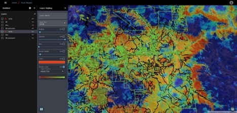
Figure 1: Eagle County with Moisture Levels and Parcels
For Bintel, this is our backyard in Colorado. Our original office above Boulder has been under fire evacuation alert or close to it three times in three years. Calwood, Sunshine Canyon and of course the Marshall Fire disaster. The Sunshine Canyon Fire that evacuated our neighborhood underscored the extreme and varied communications issues faced by our firefighters and neighbors. This issue is personal for us.
In the West, the drivers for better intelligence are fire and water and when it comes to fire, our communities issue a foundational informational document commonly referred to as a Community Wildfire Protection Plan or CWPP.
Community Wildfire Protection Plans (CWPPs) emerged out of federal legislation passed by Congress in 2003. The CWPP is a collaborative effort involving stakeholders who have a common interest in protecting shared resources within a specific region. The preparation is a substantial effort resulting in the publication of a 200+ page PDF report that must be updated every ten years.
While it serves an important purpose, when you’re confronted with a wildfire event, this document is not useful to first responders or the public.
In 2023 with a progressive team in Eagle County, CO, we built a “dynamic CWPP platform” that can be updated and published online to all stakeholders. The initial application and base layers are completed and available for demonstration to adjacent counties.
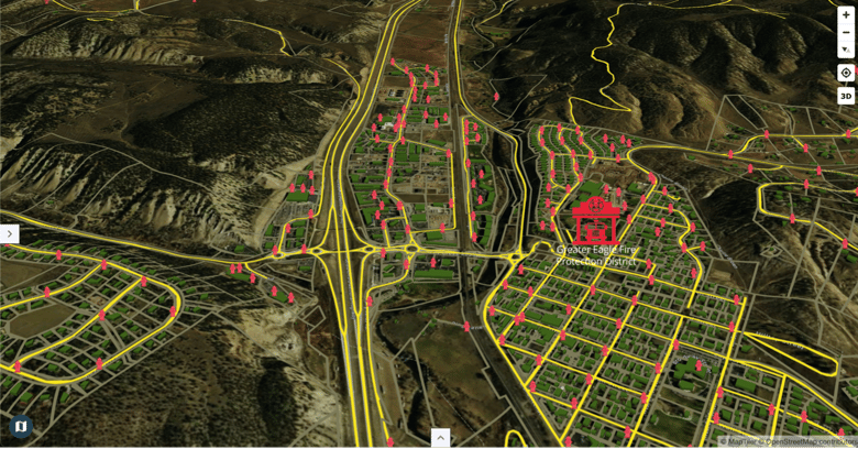
Figure 2: Eagle County I-70 Corridor with Fire Station and Fire Hydrant Locations
While we have a broader long term product vision, in this effort we have been addressing some of the ten central themes identified in the National Forest Foundation 2022 Wildfire Crisis Strategy Roundtables Synthesis Report:
- Improve internal and external communication related to a crisis and what is necessary for success.
- Update partnership mechanisms and requirements for cross-boundary funding and implementation.
- Build equity and resilience into planning and implementation.
- Invest in open and transparent information sharing and use of shared data and models.
In the case of CWPPs, the resources are community-centric, and the threat focus is wildland fire. Adding to the risk created by drought and climate change, the expansion of residential building into previously undeveloped natural areas has expanded regions referred to as the wilderness urban interface (WUI). CWPPs are intended to help communities improve understanding and preparation through risk assessment and identification, coordinated mitigation activities, education and outreach.
Ironically, the typical deliverable for these projects is anything but dynamic or reflecting these characteristics. In fact, it is often a lengthy, static PDF document (often 100–200 pages), pages of static maps, and more recently, static content displayed on an unmanaged website or “story map”.
For CWPPs to be meaningful and valuable to the communities they serve, they need to be temporally relevant, easily accessible, understandable, and cost-effective to maintain and sustain. The information in these plans should be updated continually. The need for updates varies by plan component, but when the need exists, the update should not be postponed or prolonged.
At Bintel we’re constantly addressing these issues with our clients. We look forward to expanding the platform to include apps for home assessment, mitigation planning, and additional fire simulations. It goes without saying the fire doesn’t respect county, state or federal boundaries. Time is of the essence.
For more on this from Bintel and to learn about how we can help with your CWPP, contact us here.

Tom has served as CEO of Bintel since cofounding the company in 2019. Prior he was COO of ai-one inc. where he led projects for NASA Marshall, SwissRe, Boeing and FedEx. For the past 15 years he has specialized in artificial intelligence applications for enterprise and government with a critical integration of Subject Matter Experts, AI, data, and visualizations. A project with an Army military intelligence group for the development of a Nextgen intelligence platform included GEOINT and provided situational awareness for a military ally. His current mission is to bring that caliber of solutions to counties in the West. Tom is an expert in the application of AI to text analytics, data visualization, data governance and knowledge management. He has international experience in startup, turnaround, and growth situations. Prior to Bintel, Tom was CEO of a data management business in SE Asia, and public company Viking Systems, a supplier of 3D vision systems for surgery. Tom began his career with a tech startup in Chicago followed by the acquisition of a software company serving the oil industry. Tom attended Williams College (3 years) majoring in Economics with minor in Environmental Studies.
